About Muni lagoon
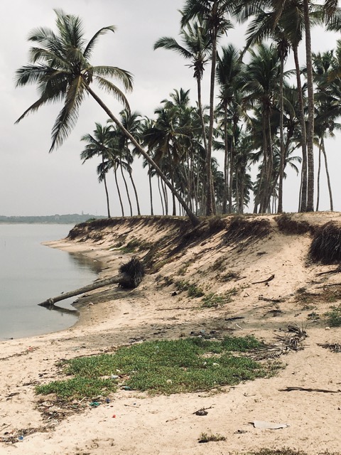
The Muni Pomadze lagoon is situated on Ghana’s central coastline, 60 km west of Accra. The lagoon is separated from the ocean by a 2 km long beach bar that is permanently connected to land at its eastern side. Three small rivers drain into the lagoon with a catchment area of approximately 90 km2. The discharge of these rivers fluctuates greatly between wet and dry seasons. At the end of the major wet season in late June the height of the water in the lagoon can reach a maximum of 2 m and the lagoon covers approximately 1000 ha but by the end of the dry season the area covered by water shrinks to as little as 100 ha and salinity can be higher than the adjacent ocean. Breaching and the creation of a tidal inlet at the western end of the lagoon barrier releases lagoon fresh water to the ocean while allowing ocean water to enter the lagoon and is thus a control on the volume and salinity of the water. It has commonly taken place at the end of the heaviest rainy seasons, when water levels in the lagoon are at maximum height. Breaching does not occur every year and in some instances the local community will create a breach to prevent flooding of their properties. The breach closes during the dry season by deposition of sand transported by longshore ocean currents.

Muni lagoon is situated adjacent to the town of Winneba, which is located approximately 60km west of the Ghanaian capital Accra. It is the home of the University of Education-Winneba and has a total population of about 60,000. However, as with all coastal towns in Ghana its population is growing and the town is expanding. A small fishing community is located directly on the Muni lagoon sand barrier and its inhabitants are dependent on the lagoon and coastal waters for their livelihood.
Potential impacts of climate change and anthropogenic activities
A rising population is resulting in increasingly polluted run-off into the lagoon, which has resulted in reduced water quality. The water quality is worst when the lagoon is closed and not flushed by the ocean. The rising population has also led to the impingement of building developments on the lagoon shores. Until the 1990s mangroves proliferated in the lagoon. However, they are virtually non-existent in the lagoon now due to illegal harvesting as firewood used for cooking and smoking fish catch prior to selling.
Shoreline retreat and erosion has been observed and attributed to sea level rise. Projections of sea level have confirmed the vulnerability and continued loss of the barrier. Changes to the timing and extent of the rainy season has been recorded. This can disrupt the opening and closing of the lagoon, increasing the potential lagoon-side flooding.


What is significant/important about this lagoon?
This lagoon was designated as a Ramsar site, a wetland site of international importance, in 1992. It was designated as such because of its habitat diversity and its globally importance as a staging post for migrating waterbirds. The globally significant biodiversity of the site makes it a potential destination for eco-tourism. The lagoon is also the site of the annual Aboakyer festival of the local Effutu people. This is a hunting festival of national cultural significance that attracts local tourists to the area.
How does this case study help to grow knowledge and understanding of lagoon environments?
The Ramsar status means that Muni lagoon has been the site of multiple research studies. These include studies of impacts of sea level rise and climate change to understand the changes expected to the lagoon and the barrier.
Research articles about this lagoon are listed in our reference section.
